
A New Perspective On the World
What is the butterfly effect?
Simply put, it is when a seemingly s
mall act, such as the flapping of a butterfly’s wings, can cause an earth-shattering change. The example usually given is that a butterfly’s wings waving in the air could later cause a typhoon miles away. While searching for a topic for my Theory of Knowledge class, I
stumbled upon a typhoon.
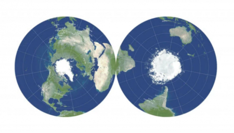
A New York Times article by Joshua Sokol featured the idea that there was a new configuration of map drawing that Princeton astrophysicist J. Richard Gott had recently discovered. The issue when making maps has been”…a mathematical incision, often running from pole to pole down the Pacific. The resulting shape can never again be stretched and pulled back into the unbroken surface of a sphere.” Before, it was mathematically impossible to create an accurate map because a round earth can’t be perfectly placed on a flat surface. Gott found a solution. He put the map on two sides of a coin. The line of the pole that couldn’t before be distorted or cut is now wrapped nicely around two flat sides.
So to sum up, all the maps that we have looked at our entire lives, are wrong. The most common maps used today were actually made as far back as 1569. Our most common way of seeing our countries align with each other is from a map that was made before people had basic hygiene. The biases and misconceptions back then are still influencing the way we think about our world today.
The International Cartographers Association suggests parts of the map were specifically drawn for the purpose of imposing a political agenda. For example, in most maps, Iceland and Africa are drawn as the same size when Iceland is really about 12 times smaller. Europe is drawn roughly the size of South America although South America is almost double its size. As a society, we use size to justify how powerful or important something is. This is reflected in our maps and subconsciously influences how we view certain countries. The bigger the country or continent, the more intimidating and powerful, right? Common people as well as intellectuals back when maps were first being made were more subject to political or social bias than ever before. Reading hadn’t become common yet so they weren’t inclined to look for other sources of information past their monarch or church. With this perspective, a cartographer in Europe would have no trouble assuming that their continent is much bigger, and therefore more powerful than the rest of the world. Another cartographer who is trying to convince his government that it would be easy to cross the Atlantic Ocean to the New World would want to make the ocean look smaller than it is in reality.
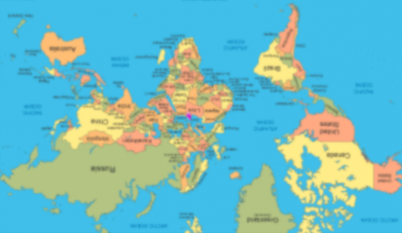
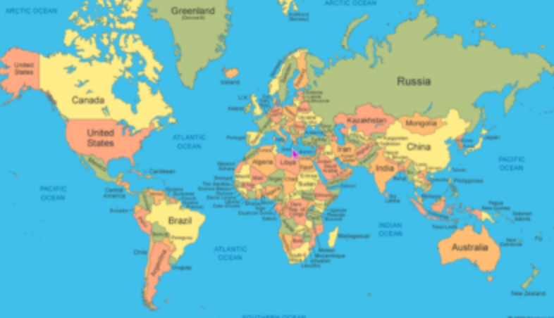
Taking this concept one step further, the International Cartographers Association suggests that because of the way the world is presented on a map, we even think of countries in the northern hemisphere as superior to those in the southern hemisphere. We usually see maps drawn “right side up”, but couldn’t they easily be flipped (image 1 and 2 above)? After finding this out, I was left questioning my justification for why the map needs to be drawn “right side up”. It had never occurred to me that an upside-down map would just show the same world at a different, but still correct, angle because the earth is a rotating sphere. If you really think about it, as an American student, what is your perspective about each country? Do the countries you see as more advanced happen to be in the northern hemisphere?
In the 1500s, when several biased butterflies wanted to map the world, they created a future in which modern society would subconsciously view each country with those same medieval assumptions (this would be the typhoon). If something like this can be happening before us and go unnoticed, I can’t help but wonder what other basic facts of life are subconsciously influencing us and changing our perception of the world to be incorrect. How will we really know what is true if it comes from values held centuries before our time?